Tag: NIHSA

  • NIHSA issues flood alert for 32 States, 832 communities

    NIHSA issues flood alert for 32 States, 832 communities

    The Nigeria Hydrological Services Agency (NIHSA) has issued a fresh flood alert for 198 LGAs across 32 states and the FCT. The agency warned of high to very high flood risks between Aug. 7 and Aug. 21.

    The alert, with reference No: 32-25-003-06, was issued by NIHSA Director General,  Mr Umar Ibrahim on Thursday, following rising river levels and persistent rainfall across the country.

    NIHSA warned that over 100 communities and major transportation routes may experience severe disruptions during the forecast period.

    The affected states include; Adamawa, Akwa Ibom, Anambra, Bauchi, Bayelsa, Benue, Borno, Cross River, Delta, Ebonyi, Edo, FCT, Gombe, Imo, Jigawa, Kaduna, Kebbi, Kogi, Kwara, Lagos, and Nasarawa.

    Others are: Niger, Ogun, Ondo, Plateau, Rivers, Sokoto, Taraba, Yobe, and Zamfara.

    According to the agency, a total of 198 LGAs and 832 communities fall within the projected flood impact zone.

    “Possible disruption of major transportation routes is anticipated,” NIHSA stated, citing data from its colour-coded flood risk map.

    The agency urged emergency management stakeholders to activate their response protocols and advised that evacuation plans be put in place for communities at risk.

    NIHSA also encouraged residents and stakeholders to follow its weekly state-level and community-specific forecasts, and to stay informed via the NIHSA flood dashboard and official social media platforms.

    The alert is part of NIHSA’s ongoing efforts to mitigate the growing impact of seasonal flooding, which continues to displace thousands and damage infrastructure annually.

    For more information and real-time updates, members of the public are advised to visit www.nihsa.gov.ng or scan the QR code featured on the official alert.

  • JUST IN: Okene-Lokoja-Abuja road likely to be affected by flood – NIHSA warns

    JUST IN: Okene-Lokoja-Abuja road likely to be affected by flood – NIHSA warns

    The Okene-Lokoja-Abuja road is likely to be affected by flood, the Nigeria Hydrological Services Agency (NIHSA) has revealed.

    TheNewsGuru.com (TNG) reports NIHSA revealed this in a flood notification issued on 21st July for Kogi State with alert level at warning stage.

    According to the agency, the forecast period is for 22nd July to 5th August 2025 with several local government areas in the State predicted to be affected.

    While NIHSA advised citizens to stay alert, the agency disclosed that communities in Ajaokuta, Bassa, Ibaji, Idah, Igalamela-Odolu, Lokoja, Ofu and Omala will be affected.

    The agency had also earlier stated that within the forecast period, over 100 major roads, including federal highways, would be affected by flood.

    “Between July 22 and August 05, over 100 major transportation routes may face disruption due to flooding.

    “This includes federal highways and state roads critical for commerce and movement, such as: Okene-Lokoja-Abuja road, Birnin Kebbi-Bunza road, Ibi-Wukari road and key routes in Lagos, FCT, and the Niger Delta.

    “There’s an increased risk of property damage to homes, businesses, and critical infrastructure in low-lying and flood-prone areas.

    “Agricultural lands are also under threat, potentially impacting food security across several regions,” NIHSA stated.

  • NIHSA issues flood alert for 28 states, 739 communities

    NIHSA issues flood alert for 28 states, 739 communities

    The Nigeria Hydrological Services Agency (NIHSA) has issued a fresh flood alert for 28 states and the FCT.

    The agency warned of a high risk of flooding in over 739 communities and 162 Local Government Areas between Tuesday and Aug. 5.

    This is contained in a statement issued by NIHSA’s Director General, Mr Umar Mohammad, who explained that the alert followed the agency’s forecast.

    This, he said, was consistent with the agency’s 2025 Annual Flood Outlook (AFO) released on April 10.

    According to the statement, NIHSA provides weekly flood alerts to highlight areas likely to experience flooding.

    States on the alert list included Adamawa, Akwa Ibom, Anambra, Bauchi, Bayelsa, Benue, Borno, Cross River, Delta, Ebonyi, Edo, FCT, Gombe, Imo, Jigawa, Kebbi, Kogi, Kwara and Lagos.

    Others were Nasarawa, Niger, Ondo, Plateau, Rivers, Sokoto, Taraba, and Yobe.

    The agency urged emergency management stakeholders to activate preparedness and response mechanisms.

    “The intensity and impact of the floods will vary across the affected states during the forecast period,” it said.

    The agency said the warning covered 28 states, beginning from Adamawa through to Yobe in the North East.

    It added that key metropolitan areas such as the FCT and Lagos State were included.

    The agency warned of the potential disruption of over 100 major transportation routes, including critical economic corridors.

    Such corridors, it said , included Okene-Lokoja-Abuja Road, Birnin Kebbi-Bunza Road, Ibi-Wukari Road, and key routes within Lagos, FCT, and the Niger Delta.

    “There is also an increased risk of property damage to homes, businesses, and critical infrastructure in low-lying and flood-prone areas.

    “In addition, agricultural lands are under threat, potentially affecting food security in several regions,” it said.

    NIHSA strongly advised all emergency management stakeholders to activate preparedness and response protocols, while at-risk communities should implement evacuation plans without delay.

    It urged Nigerians to monitor weekly updates through NIHSA’s Flood Dashboard website (www.nihsa.gov.ng) and social media platforms.

  • Real cause of Mokwa flood disaster revealed as death toll rises

    Real cause of Mokwa flood disaster revealed as death toll rises

    The Nigeria Hydrological Services Agency (NIHSA) has revealed the real cause of the devastating flood disaster that ravaged Mokwa town in Mokwa local government area of Niger State.

    TheNewsGuru.com (TNG) reports Mrs Awoibi Joe-Ukairo, Director of Planning, Research and Statistics at NIHSA, to have attributed the Mokwa flooding to anthropogenic activities in that area.

    Speaking on Arise TV News Night programme on Tuesday, Mrs Joe-Ukairo disclosed that NIHSA’s Director-General, Umar Mohammed reported this from a visit to Mokwa to assess the situation.

    “We had predicted that it was going to flood in that area. In fact, we have what we call the flash flood dashboard. On it, Mokwa was indicated to be at a high risk for flooding for between April to June.

    “So, what we are seeing was already predicted. The alerts were there. The information was sent out like we usually would do. But, unfortunately, in this particular incident, the flooding is a result of anthropogenic activities, that is, human contributed activity in that area,” Joe-Ukairo said.

    While commiserating with victims of the Mokwa flood disaster, the NIHSA Director said, “We are saddened by the incident. As much as we make our predictions, we really do not want to see the fatalities that take place as a result of the event”.

    Speaking further, she said, “There was a construction work that took place in that area and there is this River Dingi, a tributary to River Niger.

    “When this construction took place, it blocked the water flow path to the major River Niger and over time built up ponds of water in that location.

    “A temporary embankment was made and you know how water is, it will always find its way and take its course.

    “So, when this rain started on Wednesday, it was intense and went on for a longer time. The embankment soaked up water and gave way.

    “Because this construction had gone on there, it stopped the flow to the other side, which became like a reclaimed land and people went to build houses there.

    “The river was a seasonal river. So, people felt it was okay to live there and that is why you are seeing the high number of fatalities. People began to inhabit the place. A lot of people.

    “This is really a saddening situation for us. As much as we predict, we hope that people will heed to the predictions and take precautions so that we do not have what we have now”.

    The NIHSA Director added: “Prediction is also a mitigation measure. That is why we come out earlier in the year before the rain starts.

    “In the past, we will predict for the State and for the local government, but this year’s annual flood outlook, we predicted down to the communities.

    “That is why you can see that we picked up this particular community as a high risk vulnerable community that is going to be impacted by flood. We have the high risk areas and the moderate areas. Mokwa was on high risk.

    TNG reports over 1,200 communities are at high risk, more than 2,000 are at moderate risk and cities like Abuja and Lagos have been flagged, according to the annual flood outlook.

    Mokwa flood: 7 more bodies recovered

    Meanwhile, the Niger State Government has announced the recovery of additional seven bodies from the flood disaster in Mokwa, bringing the number of casualties to 160.

    This is contained in a statement on Tuesday in Minna by the Secretary to the State Government, Abubakar Usman.

    According to Usman, four of the bodies were recovered on Monday and one body was recovered in the early hours of Tuesday, while two more bodies were recovered on Tuesday in the ongoing search efforts.

    He said the recovered bodies had since been buried.

    “This development brings the total number of confirmed fatalities from the flood to 160.

    “The State Government wishes to appeal to residents and the general public to remain calm and prayerful in this moment of collective grief.

    “We urge everyone to avoid spreading unverified or misleading information that may further deepen sorrow, incite panic, or cause unnecessary confusion within our communities.

    “While we continue to mourn the lives lost, the government remains committed to providing the necessary support to affected families and intensifying rescue and relief efforts where needed,” the statement added.

  • FG raises alarm Lagos, Delta, Bayelsa, 30 other States at high risk of flooding [SEE FULL LIST]

    FG raises alarm Lagos, Delta, Bayelsa, 30 other States at high risk of flooding [SEE FULL LIST]

    The Nigeria Hydrological Services Agency (NIHSA) has warned that 1,249 communities across 176 Local Government Areas (LGAs) in 33 states and the FCT fall within the high flood-risk areas in 2025.

    The warning was issued during the official presentation of the 2025 Annual Flood Outlook (AFO) by the Minister of Water Resources and Sanitation, Prof. Joseph Utsev, in Abuja.

    According to the forecast, an additional 2,187 communities in 293 LGAs across 31 states and the FCT are expected to experience moderate flood risk this year.

    States identified in the high-risk category include: Abia, Adamawa, Akwa Ibom, Anambra, Bauchi, Bayelsa, Benue, Borno, Cross River, Delta, Ebonyi, Edo, the FCT, Gombe and Imo.

    Others are; Jigawa, Kebbi, Kogi, Kwara, Lagos, Nasarawa, Niger, Ogun, Ondo, Osun, Oyo, Rivers, Sokoto, Taraba, Yobe, and Zamfara.

    Utsev noted that floods are among the most devastating natural disasters affecting lives, property, agriculture, and infrastructure.

    He said the 2025 forecast is aimed at raising awareness and encouraging preparedness among citizens, particularly in vulnerable communities.

    He said this year’s theme on community preparedness and adaptation is timely, given the recurring floods and their impact on livelihoods and infrastructure.

    The minister explained that the 2025 Annual Flood Outlook has been segmented into three parts to enhance flood preparedness.

    These include a general flood forecast, a communication strategy for effective warning dissemination, and a mitigation plan to reduce exposure and vulnerability.

    “According to the forecast, 657 communities in 52 LGAs are expected to experience high flood risk between April and June.

    “544 communities in 142 LGAs between July and September; and 484 communities in 56 LGAs from October to November.

    “Moderate flood risk is projected for 445 communities in 116 LGAs from April to June, 1,458 communities in 271 LGAs from July to September, and 1,473 communities in 171 LGAs between October and November,” he added.

    He said flash and urban flooding are expected in major cities, including Abuja, Lagos, Port Harcourt, Ibadan, Kano, and Makurdi, largely due to poor drainage and weak infrastructure.

    According to him, coastal states such as Bayelsa, Cross River, Delta, Lagos, Ogun, Rivers, and Ondo may also experience flooding caused by rising sea levels and tidal surges, posing a threat to livelihoods and river-based activities.

    Utsev announced initiatives such as a National Flood Insurance Programme, to be piloted in Kogi and Jigawa states, and the Niger Flood Project to boost river navigation, flood control, and climate resilience.

    He highlighted plans to launch an Integrated Climate Resilience Project and the forthcoming Annual Drought Outlook.

    Utsev urged stakeholders to support government efforts in building flood-resilient communities and affirming the Federal Government’s commitment to proactive flood management.

    Earlier, the NIHSA Director-General Umar Mohammed emphasised the agency’s commitment to using advanced technologies and fostering inter-agency collaboration to deliver accurate and timely flood forecasts.

    Mohammed explained that this year’s forecast adopts a more community-focused approach, extending beyond local government areas to identify specific at-risk communities.

    “Our aim is to equip decision-makers with actionable information to protect lives, livelihoods, and property,” he stated.

    He added that the outlook identifies flood-prone states, local government areas, and communities, while also assessing impacts on sectors such as healthcare, education, agriculture, transport, and water quality.

    According to Mohammed, the goal is to strengthen community resilience and support proactive flood management strategies across the country.

    Key highlights of the event included the formal presentation of the NIHSA Flood and Drought Dashboard and the unveiling of the National Flood Insurance Programme.

    Goodwill messages were delivered by representatives of the World Meteorological Agency, the National Water Resources Institute Kaduna, and others.

  • River Niger water levels under control, says NIHSA

    River Niger water levels under control, says NIHSA

    The Nigeria Hydrological Services Agency (NIHSA) has assured Nigerians that water levels in the River Niger are under control as the country prepares for potential flooding.

    NIHSA’s Director-General, Mr Umar Mohammed, who made this known in a statement on Tuesday in Abuja, noted the importance of adhering to flood preparedness protocols.

    He said that water levels in the River Niger Basin have been gradually receding since early October, adding that Jebba Dam is currently spilling excess water in coordination with operators of the Kainji Dam.

    “The Kainji Dam has maintained a 53-centimetre buffer to manage any changes in water inflow.

    “NIHSA, through our Director of Operational Hydrology, Mr Femi Bejide, is working closely with the operators of Kainji and Jebba Dams to ensure effective reservoir management,” Mohammed stated.

    The director general noted that despite the rainy season gradually shifting southward, water is still entering Nigeria, as monitored by NIHSA’s stations at Jidere Bode and Kende.

    He reaffirmed NIHSA’s commitment to working with dam authorities both nationally and internationally to mitigate river flooding and support Nigeria’s socio-economic growth.

    Mohammed added that the agency will continue to monitor weather patterns and water inflows, urging communities in flood-prone areas to stay vigilant and adhere to all safety guidelines.

    NAN reports that NIHSA’s 2024 Annual Flood Outlook reveals that 148 Local Government Areas (LGAs) across 31 states are at high risk of flooding.

    The affected states include Adamawa, Akwa-Ibom, Anambra, Bauchi, Bayelsa, Benue, Borno, Cross River, Delta, Ebonyi, Edo, Imo, Jigawa, Kaduna, Kano, Katsina and Kebbi.

    Others are Kogi, Kwara, Lagos, Nasarawa, Niger, Ogun, Ondo, Osun, Oyo, Plateau, Rivers, Sokoto, Taraba and Yobe.

    The agency had on Sept. 25, has issued a warning about the rising water levels, which it said have steadily risen.

  • GOOD NEWS: Risk of severe flood lowers as River Benue water level recedes

    GOOD NEWS: Risk of severe flood lowers as River Benue water level recedes

    The Nigeria Hydrological Services Agency (NIHSA) has announced a slight decrease in River Benue’s water levels in recent days, lowering the risk of severe flooding.

    NIHSA’s Director-General, Mr Umar Mohammed, disclosed this in a statement issued on Saturday in Abuja.

    Mohammed reaffirmed the agency’s commitment to monitoring the water levels of the nation’s major rivers and tributaries, as part of its overall flood management strategy in Nigeria.

    He urged citizens to remain vigilant due to unpredictable climate conditions and to continue observing flood preparedness protocols.

    “NIHSA is working closely with the authorities and management of Lagdo Dam regarding water releases, and the agency is committed to monitoring water levels at critical stations,” he said.

    NIHSA’s 2024 Annual Flood Outlook reveals that 148 Local Government Areas (LGAs) across 31 states are at high risk of flooding.

    The affected states include Adamawa, Akwa-Ibom, Anambra, Bauchi, Bayelsa, Benue, Borno, Cross River, Delta, Ebonyi, Edo, Imo, Jigawa, Kaduna, Kano, Katsina and Kebbi.

    Others are Kogi, Kwara, Lagos, Nasarawa, Niger, Ogun, Ondo, Osun, Oyo, Plateau, Rivers, Sokoto, Taraba and Yobe.

  • Flood: Rivers approach danger thresholds in Kogi

    Flood: Rivers approach danger thresholds in Kogi

    The National Orientation Agency (NOA) has urged communities in flood-prone areas to immediately relocate to highland as the Benue and Niger rivers approached danger thresholds.

    The Director-General of NOA, Lanre Issa-Onilu, gave the advice on Thursday when he led the “NOA Flood Sensitisation and Evaluation Team” to sensitise some reverine communities in Kogi State.

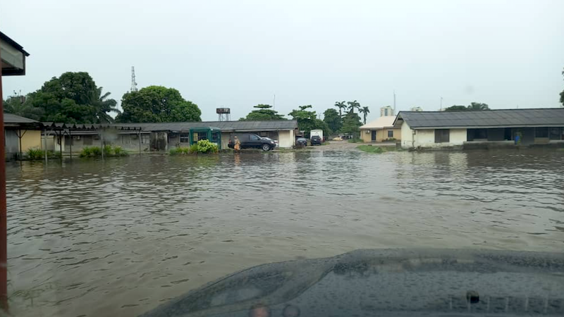
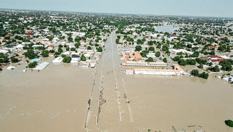
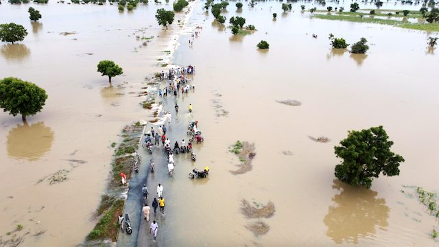
    The water level of Benue and Niger rivers had risen to about 9.2m  on Sept. 25, compared to the usual level of about five meters, according to Kogi State Emergency Management Agency (SEMA).

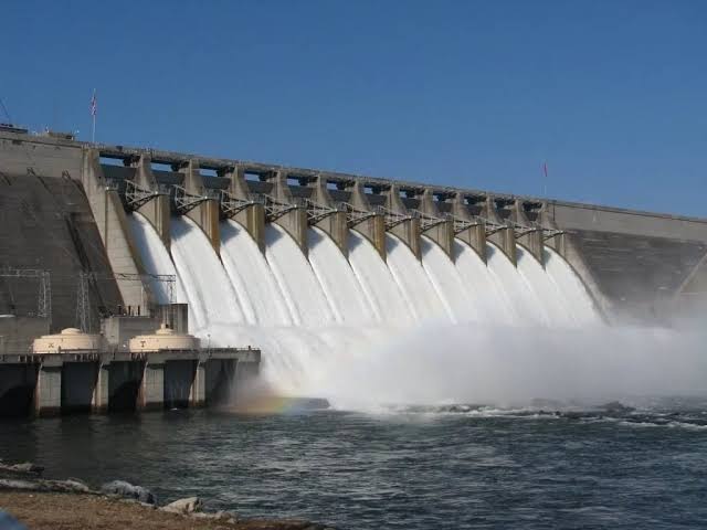
    The NOA DG said the release of water from Cameroon’s Lagdo Dam could cause a significant flooding and environmental damage in Nigeria especially in 11 States as predicted by the National Hydrological Information Service (NIHSA).

    Issa-Onilu, who was represented by the NOA Director of Planning, Research and Statistics (PRS), Abuja, Malam Nuru Kobi, stressed that the flood disaster was imminent, and urged people in riverine communities to seek shelter in a safer place immediately.

    The DG said that NOA was alerting the populace especially the frontline States, which include Kogi. Adamawa, Nassarawa, Taraba, Benue, Anambra, Delta, Edo, Cross River, Balyesa and Rivers.

    He noted that NOA had constituted a Flood Sensitisation and Evaluation team, who were going round the 11 States along the river Benue basin to sensitise the communities to move to highlands.

    “We have opened all our channels of communication on flood alert in NOA to kick-start sensitisation. NOA has already mobilised all our officers in those 11 States go round and sensitise all the communities to be impacted negatively by the release of the Camaroon’s Lagdo Dam.

    “Like in Kogi, we have five local government areas that will be affected which includes Lokoja, Kogi, Omala, Ajaokuta, Idah and Ibaji. What we are doing now is called ‘Risk communication’, to evaluate the risk and then advise them accordingly.

    “So, we are visiting communities, markets, religious centres and traditional leaders, to sensitise the people especially in the flood prone areas to move to upland,” he said.

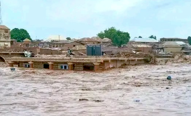
    He noted that over 600 lives were lost and about 10,000 houses submerged during the 2022 flood disaster, stressing that the federal government is taking proactive measures to mitigate flood disaster Incase of eventuality in 2024.

    The NOA DG commended Kogi Government for putting proactive measures in place that would mitigate the devastating flood effects in the flood -prone areas.

    He added: “we are happy seeing what the Kogi government has been put in place, such as the establishment of IDP camps among others. We hope that other States will emulate Kogi”.

    The State Director of NOA, Mr Abdulganiyu Dare, said the agency has been collaborating with the Kogi government and other relevant agencies to ensure that residents of riverine communities were adequately sensitised.

    “As agency with the mandate to enlightened the public about the programmes, policies and activities of government, we have been working harmoniously with SEMA and other relevant to ensure adequate sensitisation,” Dare said.

    The Executive Secretary, Kogi State Emergency Management Agency (SEMA), Muktar Atimah, said the State Governor, Alhaji Ahmed Ododo, has set up 42 Internally Displaced Persons (IDPs) camps across eight flood-prone local government areas of the state.

    He, however disclosed that Ibaji which is the nineth LGA, has almost been submerged by flood.

    Also speaking, the Special Adviser to the Governor on State Emergency Management (SEMA), Sandra Musa, said the State Government has been collaborating with the Nigerian Navy, the NEMA to monitor the water level on daily basis.

    “As of today, the water level of Benue and Niger rivers has risen to about 9.2 meters compared to the usual level of about five meters,”: she said.

    She, therefore advised the people in the flood prone areas to immediately evacuate to save their lives and valuables.

    Speaking on behalf of Edeha community, the traditional ruler, Alhaji Abdullahi Isah, commended NOA for coming to sensitise their people.

    He, however appealed to both federal and state governments through their relevant agencies to construct permanent structures with basic facilities as IDPs, instead of using schools that lack the required minimum facilities.

    “As I am talking to you now, our community has been submerged including my own house, so we have no choice than to relocate to a safer place.

    “But we are appealing to government at all levels to construct permanent structures as IDPs instead of using schools which lack basic facilities and cannot even accommodate all of us”, Isah said.

    NOA sensitisation and evaluation team also paid an advocacy visit to the palace of the Maigari of Lokoja, Alhaji Ibrahim Gambo, who commended the agency for the initiative, and assured them of support and cooperation.

    The team also visited riverine Kabawa community in Lokoja, Edeha community in Koton-Karfe/Kogi and 500 Housing Estate in Ajaokuta.

    Some flood victims, who were seeing evacuating their belongings in some of the communities visited, appealed for governments’ support.

    Mrs Sukirat Jimoh, a mother of five; and Mr Umar Jimba, told NAN that their houses had been flooded, adding that the waters were rising everyday.

    “We are appealing to the federal and state governments to come to our aids,” Jimoh said.

  • BREAKING: FG sounds alarm as Cameroon ‘opens’ Lagdo Dam

    BREAKING: FG sounds alarm as Cameroon ‘opens’ Lagdo Dam

    The federal government of Nigeria has disclosed that the management of Lagdo Dam in Cameroon is set to release water from the reservoir, beginning from today 17th September, 2023. The Nigeria Hydrological Services Agency (NIHSA) made the disclosure on behalf of the government.

    TheNewsGuru.com (TNG) reports Lagdo Dam is a reservoir, covering an area of 586 km sq, located in the Northern Province of Cameroon on the Benue River in the Niger basin.

    According to the NIHSA, States that are susceptible to be affected by the release of water from the Lagdo Dam are Adamawa, Taraba, Benue, Nasarawa, Kogi, Edo, Delta, Anambra, Bayelsa, Cross River and Rivers.

    The States have been advised to step up vigilance and deploy adequate preparedness measures to reduce possible impacts of flooding that may occur as a result of increase in flow levels of the major rivers in the country as a result of the release of the water.

    Speaking on Tuesday in Abuja, Director General of NIHSA, Mr Umar Mohammed, stated that “following an official communication from the dam’s management, the water release will gradually increase over the next seven days”.

    According to him, the initial release rate is set at 100 cubic meters per second (approximately 8.64 million cubic meters per day) starting Sept. 17, 2024, with  potential increase to 1,000 cubic meters per second.

    He noted that the final rate will depend on inflows from the upstream Garoua River, the primary source of the reservoir, which also feeds into the Benue River, a key waterway in Nigeria.

    “The release will be regulated to ensure that water levels do not exceed the capacity of the Benue River system, preventing major flooding in downstream areas of Nigeria,” he added.

    He reassured the public that measures are in place to control the flow and reduce flooding risk, with the release stopping once inflows to the Lagdo reservoir is manageable. He emphasised that there is no immediate cause for alarm, as water levels along the Benue River remain within safe limits.

    He urged heightened vigilance from states bordering the Benue River, including Adamawa, Taraba, Benue, Nasarawa, Kogi, Edo, Delta, Anambra, Bayelsa, Cross River and Rivers. He called on both federal and state governments, as well as local authorities, to prepare adequately for any potential rise in water levels to mitigate the risk of flooding.

    Mohammed also assured the public that “NIHSA will continue to monitor river flow levels closely and provide regular updates to prevent emergencies.”

    Recall that recently, the Niger Basin Authority has also warned of rising water levels in the River Niger, urging States along the river to remain on high alert for possible flooding.

  • BREAKING: FG raises alarm as River Niger rises above normal level

    BREAKING: FG raises alarm as River Niger rises above normal level

    The federal government has raised an alarm and warned the general public over the rising water levels of the River Niger system. The Nigeria Hydrological Services Agency (NIHSA) raised the alarm on Friday.

    Mr Umar Mohammed,  the Director General of NIHSA in a statement noted that floodwaters from countries in the River Niger system are gradually moving towards Nigeria, starting with Kebbi State.

    According to the agency, the development is attributed to upstream activities in Niger Republic and Mali, and with reports from the Niger Basin Authority (NBA) in Niamey, Niger Republic.

    NIHSA assures that dam operators at Kainji and Jebba, situated on the River Niger, have been informed and are on standby.

    “As of August 22, the agency confirmed that these dams are not currently spilling water from their reservoirs,” the statement reads.

    The D-G said the risk of flooding is expected to peak by the end of August and into September, urging States and communities along the River Niger system to remain vigilant.

    He said the agency will continue to monitor the situation closely and provide regular updates to the public.